 Maps © Mapbox and © OpenStreetMap
I’ve been blessed with almost 40 night’s sleep in the Pyrenees, not including buildings. And if we assume I ate couscous every night (and why wouldn’t we), that’s… a lot of olive oil.
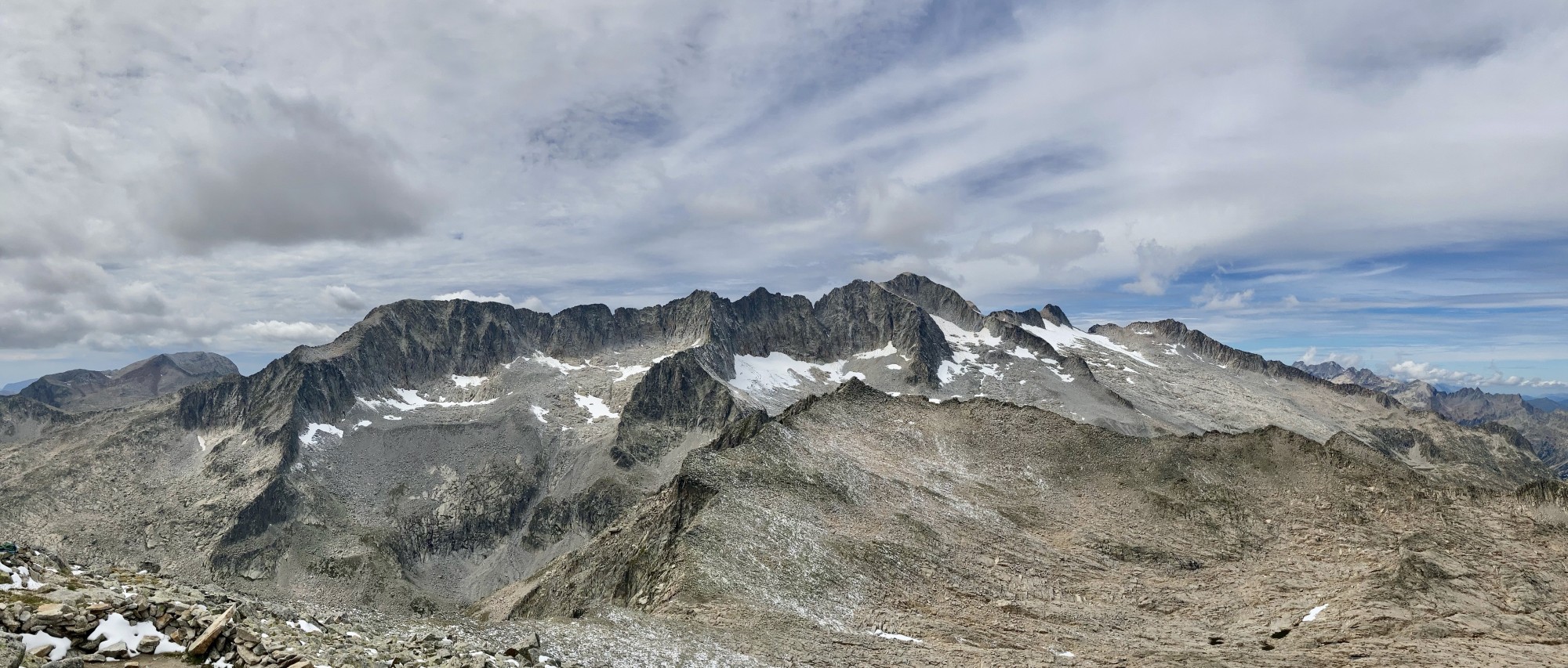
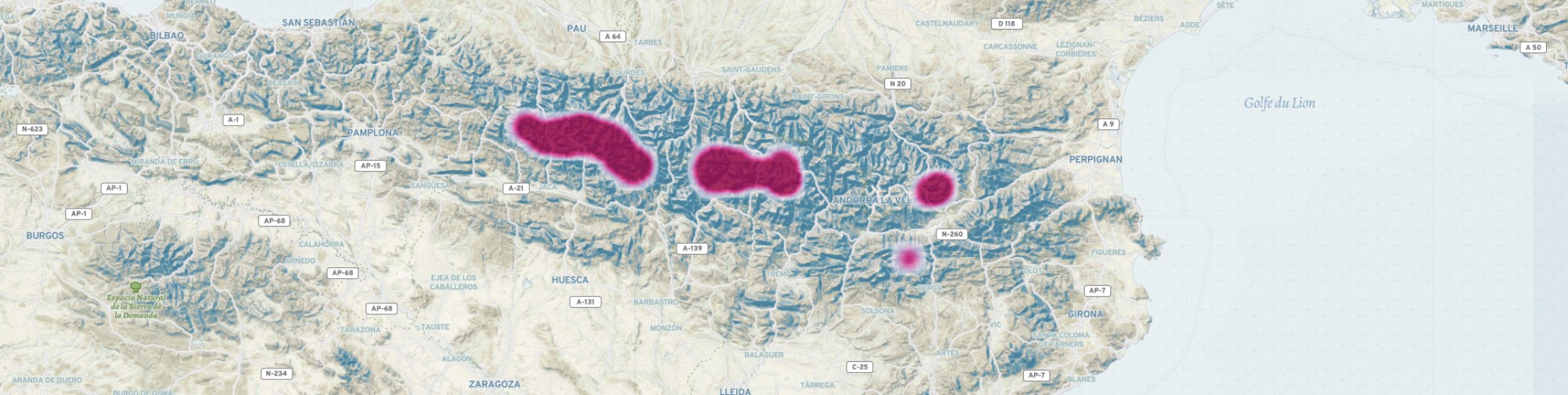
The map below is some kind of heat map of the roughly eight outings I’ve had in this beautiful mountain range, from my first in 2015, to my most recent a few weeks ago. Although we’re shortly leaving Spain, I expect I’ll be back to the Pyrenees before long. In the meantime, I thought I’d share some brief thoughts and photos from some of these outings. Note: if there are any good photos, they were taken by Esteban or Javier. I’m just the freeloader.
(Scroll, pinch, or double-click to zoom in.)
I wrote before about the days I spent climbing in the pre-Pyrenees in Catalonia in 2015. Immediately after that, Esteban invited me to join him and two friends on a 10ish day hike along the GR11, the famous hiking trail that traverses the Pyrenees from East to West (or vice versa) on the Spanish side. I had just bought my first decent hiking pack, was soon off to Georgia (the country) to climb big peaks, and so was happy to load up my pack like an amateur and call it training. So amongst other things, along came a pair of mountaineering boots (gotta break them in), my crampons (but no axe), a soft-cover edition of Joyce’s Ulysses (to be read during the following days on the Camino) and all sorts of other heavy things. My appetite for heavy things has since waned and I’ve spent lots of money on expensive gear.
I hitch-hiked to Torla, at the entrance to Ordesa, and just after the tiny tunnel, my generous drivers spotted three more hitch-hikers and picked them up too: my serendipitous hiking partners! It was my first big multi-day hike, and was quite a learning experience. Lesson number one: Spanish twenty-somethings like to sleep late. Lesson number two: if something hurts, don’t wait until the end of the day to investigate.
Despite my long slow mornings, willing the group to get going while reading furiously (not Ulysses — that would wait for the Camino), it was a beautiful and tranquil hike. The plastic buckle of my K-Way sleeping bag dug a pretty nasty hole in my back (lesson two), but a day or two of walking with my hands between my pack and me sorted that out. Nacho wasn’t so lucky: his brand new boots (lesson one for him, I’m sure) created a horrifying blister on each of his heels. On day one. This threw our plans into disarray a bit, as we had to get him back to civilisation, and this somehow caused other plans to change, and in the end it was only Esteban and me that made it all the way to the Selva de Oza. In all about eight official ‘etapas’ (day-sized bites) of the GR11.
It was a memorable hike, and kindled my love for these beautiful mountains. The crampons, by the way, were for a potential summit of Monte Perdido. I did not know that this had already been ruled out while I was carefully stowing them in my pack the day before setting out.
When Sarah and I moved to Spain, the mountains were naturally high on my agenda. So when Esteban called me, one Wednesday in March 2019, and told me to get to Benasque by the following evening, I jumped! In the intervening four years I’d spent a good deal of time outside, so my gear and food prep was a bit slicker. I met up with them standing outside a supermarket at midnight (this kind of thing happens a lot on mountain trips) and the next morning we started hiking up. Well. First they drove their cars as far up the ice-covered forest road as they could, and then we started hiking up.
We camped up high, ready to follow the Coronas Route (south side, slightly more technical than the skiable north). The next morning I did what I expected to do: woke up, got ready-ish, and waited. It was a sparkly slog up the mountain, with the sun slowly glinting off lesser peaks. Someone had warned us that there was “mixed climbing” in the crux, so we’d coiled a rope into my pack. In the end it was very straight-forward, and some careful footsteps on the mostly rock had us over the ridge and on the summit slope.[1]
The “Paso de Mahoma” (I have no idea where this name comes from) is the short exposed ridge that leads to the summit proper. It was less scary than a fish-eye GoPro would have you believe, but crampons and snow can make anything interesting. Fortunately, the summer crowd of mountain débutantes was absent, so there was no queue. And then the top of the Pyrenees! Stunning views of snow-covered mountains in every direction, and the overwhelming feeling that it was worth getting out of town for the weekend.
We descended jauntily (somehow always the case), and set up camp for the night a little way up another valley, at the confluence of two thawing streams. We pored over maps and hypothesized additional peaks, but somehow softening thigh-deep snow in every direction (post-hole!) dissuaded us. The next day everyone prepared for an afternoon of playing guitar and a night in the dusty cabin down the valley, but my allergies and I realised this sounded crap, so I raced down the mountain, past the icy-parked cars and on down the road to Benasque, making it just in time for the bus(es) back to Barcelona.
After ski-touring (relatively unsuccessfully) in Norway, sprint-hiking from somewhere to Zermatt, and another hike in the French Pyrenees with Sarah, I was feeling fit. Javier, who I’d climbed with in Georgia (the country) in 2015, and in Kyrgyzstan (likewise) in 2018, had just come back from another trip to Kyrgyzstan, this time to Lenin Peak, was also fit. We’d both been eyeing out the Pyrenees High Route (or Alta Ruta or Haute Route, as you prefer) and decided to give it a shot. It’s a relatively undefined route that runs the length of the Pyrenees, with the goal of staying as high as possible. There are several guides out there, and it seems that the English and French ones are rather tamer (the French side of the mountains is generally tamer, too) than the Spanish. We ended up following a book by someone called Gorka, who is presumably Basque and therefore a nutter in mountain terms.
But for some reason (and this was my fault) we decided to push past even his crazy days, and each day tried to go further, ultimately hoping to do in nine days what the book recommended for twelve. The main reason this was plausible is that we were (as always) camping, and so (a) not reliant on refugios but also (b) carrying much more stuff on our backs than Gorka. I’d just done 70 km and 6,100 metres in two days in the Alps, so didn’t see a problem with extending this kind of pace for nine days.
We hiked about 10 hours per day for a few days, passing sometimes two refugios in a day. A strange discomfort arriving at a refugio at 4pm, seeing others who put their feet up two hours ago — and then stomping on for three more hours. We managed to bag three peaks: Balaitous (an absolute joy), Grande Facha and Petit Vignemale. However, after four massive days, my knees started to complain. We crossed back into Spain with Monte Perdido waiting in the distance, but my hubris had brought my knees (and therefore us) to a stop, and we spent a miserably cold, rainy night in Javier’s very alpine but very not-waterproof tent, waiting for the morning to trudge down to Bujaruelo and Torla to figure out how to get home and rest my knee.
We’d still covered an incredible distance in a few days, but I realised (was it necessary?) that hiking off-path and scrambling up peaks take an extra toll compared to blasting along dual-lane Alpine trails. The Pyrenees may not have the glaciers and peaks of the Alps, but it’s certainly rougher in its way. Nonetheless, we’d set something in motion, and plans were already brewing for a return to where we’d left off!
After twice thinking I was on my way to climb Monte Perdido, and twice being thwarted, I was ecstatic to set out once again on 3 January 2020 for a third attempt — in winter! Javier picked me up in Jaca and, after the obligatory Burger King, we drove up into the mountains once again for a quick traverse over Monte Perdido.
We slept in the back of Javier’s sedan, and set off the next morning about an hour behind four others we saw heading up, who’d clearly woken up in a cozy apartment. It was a long sloggy day, through the snow and interminable shadow: the north side of the Pyrenees is an inhospitable place in winter. We picked up where we’d left off on the high route, and crossed back into France on our way to La Brecha de Rolando. Snow up to our knees and not a drop of sun all day, until just before sunset we crossed through La Brecha and back into Spain, and were bathed in soft mid-winter sun, with warm softened snow replacing the blue ice of the French side.
We camped in a small nook in the cliff-face, enjoying the flat snow that only thirty minutes of shovelling and hacking can provide. The next morning we set off on the epic traverse of the Perdido ridge, bypassing Le Casque along a very treacherous slope, and summiting La Torre (but staying well back from the massive overhanging cornice). From that point on we had a view of La Escupidera, the infamous slope that leads to the summit of Monte Perdido. Several kilometres of foreshortening had the effect that it looked impossibly vertical and scoopy, and my imagination spent the next several hours worrying about it and wondering if chess was so bad after all.
But we finally got to the end of our ridge quest, and from underneath the route didn’t look too bad, so we picked our way carefully to the summit, and had another Pyrenees 3000’er all to ourselves! Finally I’d made it to the top! We jaunted back down and slept near Refugio Goriz (why cook in the freezing cold when it’s not needed), before making our way down the chains into Ordesa valley and the long amble to complete the loop and get back to the car.
This July, from the goodness of my heart, I bought Sarah a down sleeping bag. For unrelated reasons, we immediately started planning a trip to the Pyrenees! We had our heart set on Aigüestortes, but there is a problem: camping is prohibited. Bivouacking is prohibited. Swimming is prohibited. The only things that aren’t prohibited are roads where they’re not needed, helicopters to bring food to all of the profitable refugios, and infinitely many cows.
But we had a cunning plan: to the north of the park is Val d’Aran[2] and the Circ de Colomers, which is not part of the park (and its ungenerous rules) but by all accounts just as beautiful. We were thus very unimpressed when we arrived at the parking lot and learned that it was part of the ‘Zona Periferica’, and therefore camping was still not allowed. But at this point my tent was all the way at the bottom of my pack, so we unfocused our eyes and pretended we hadn’t seen the sign.
What followed was five great days exploring every valley and lake of the Cirque, along with one trip into the park proper to climb Tuc de Ratera[3] There were too many cows (one would be too many, I think) with their attendant shit, and it’s always a bit tiring to have to wait until just before sunset before pitching the tent in a secluded spot. But we just about had to it ourselves (once an hour past the trailhead) and the combination of lakes, trees and alpine peaks makes it one of the most picturesque places I’ve ever been.
Javier and I wanted to set off from where we’d ended up the previous time (Monte Perdido, in case you aren’t paying attention) but logistics in the time of Covid are a pain, and so we settled with starting near Benasque, and heading due West to make a sideways ‘S’ shape. We planned eight days of hiking, and I was determined to treat my knees carefully and leave the hubris at home.
After a night sleeping on some concrete somewhere, we started out all alone in the wind and rain, the only people venturing past day-hike distance. We climbed nearly 2,000 metres to arrive at el Ibon de Llardaneta, where we were very happy to find a fortified ring of rocks for my very new tent — being put through its paces for the first time! The next morning we set off with slightly better weather, but still not good enough to try Las Espadas (the hard route to the top) with full packs, so we followed the normal route. It was still a great time picking our way to the summit of Posets (the second highest in the Pyrenees!), and even better following the narrow ridge down the other side. Then less great finding our way down a vertical labyrinth of cracks leading down the glacier below, followed by several hours of scree. We finally made it back something resembling a trail, just in time for the hail to start…
What followed was an absolutely beautiful but relatively unwelcome two days of snow. Snow falling from above, snow blowing from the side, and plenty of snow to trudge through underneath. The “route” wanted us to connect several peaks and ridges on our way into France; reality dictated that we take the “easy” way over the Port d’Oô (heaven knows how to pronounce that), which still involved some snowy scrambling and several hours’ route-finding in the mist. The next day the bad weather had finally broken, and we set off in a glistening paradise of snow and sun. Some more snowy scrambling took us back into France, and we started the long traverse towards Bivouacking, the Aneto massif constantly in sight.
We summited Tuc de Molières and crossed back in Catalonia, before heading into Aigüestortes for some more illegal camping. Our final big day was a massive off-trail slog to the Gran Tuc de Colomers, with nary a cairn in sight. But we made it in one piece, and after one final technical scramble to get down, we made it into the familiar territory of the Circ de Colomers that Sarah and I had explored so well one month earlier. In the end we did about 130 km and probably just over 10,000 vertical metres — not bad for a slow Covid year with eight days of food on our backs!
Needless to say, it won’t be long before I’m back. We still have a long way to go to complete the route all the way to the Mediterranean! In the meantime, I’m hoping that having cleared up this backlog of mountain mini-stories will make it easier to write about future trips in a more timely manner!
[1] go back Another data point in the slowly evolving ‘how to internalize mountain advice you receive from others’ algorithm. Relevant factors include whether or not they are Kilian Jornet, the clothes they’re wearing, and how generally grizzled they look. Irrelevant factors include age and gender, I’ve learned.
[2] go back A small would-be country with its own language and administration, within the small would-be country of Catalonia.
[3] go back In the Pyrenees, each region has its own name for lakes and peaks.